A Soggy and Cool Start to Spring Planting 2025
A Soggy and Cool Start to Spring Planting 2025
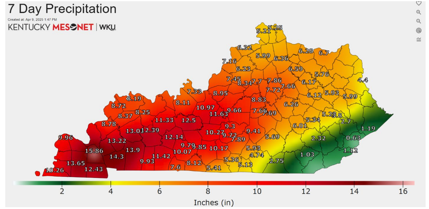
Between relentless rainfall and subfreezing temperatures, the start of this growing season has been anything but ideal. According to data from the Ag Weather Center, Kentucky averaged 7.56 inches of rain last week. However, rainfall totals varied widely across Kentucky, ranging from a staggering 15.87 inches at the Marshall County Mesonet station to a mere 0.63 inches in Letcher County. As shown in the map below, much of Western and Central Kentucky exceeded 10 inches of rainfall (map below, courtesy of the Kentucky Mesonet).
To put these figures into perspective, areas receiving more than 10 inches of rain accumulated over 20% of their annual average in just four days. Kentucky typically only averages 4.73 inches of rain for the ENTIRE month of April. Preliminary data indicates that this month’s average of 7.56 inches would rank as the fourth wettest April in state history—with more than half the month remaining. The record, set in 2011, stands at 12.07 inches.
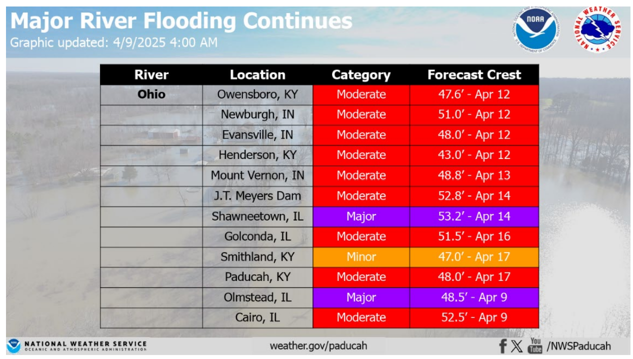
The recent rainfall has been truly historic, resulting in extensive flooding across Kentucky, with impacts expected to persist in the weeks ahead. Major and moderate river flooding remains a concern at numerous locations statewide. For detailed information specific to your area, access a clickable map featuring river gauges across Kentucky, including observed and forecast flood stages.
Looking at the data, most rivers in Central Kentucky have already reached their crest and are beginning to recede, while many Western Kentucky are projected to crest within the next week. The graphic below from the National Weather Service in Paducah provides an excellent summary of this information.
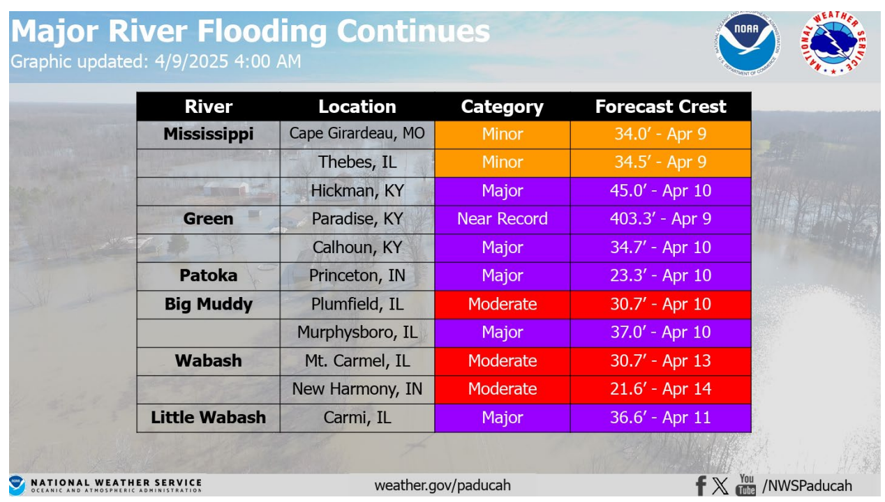
However, it’s important to note that these are forecasted crests—it will take time for the rivers to fully recede. In the Purchase area, current forecasts indicate the Ohio River at Cairo and Mississippi River at Hickman will remain in moderate flood stage through April 22nd.
Adding to the challenges posed by excessive rainfall, temperatures plummeted over the past couple of nights. With agriculture becoming increasingly vulnerable, the National Weather Service issued the first freeze warnings of the spring season. The Kentucky Mesonet recorded low temperatures on the morning of April 9th in the mid-20s to mid-30s (map below).
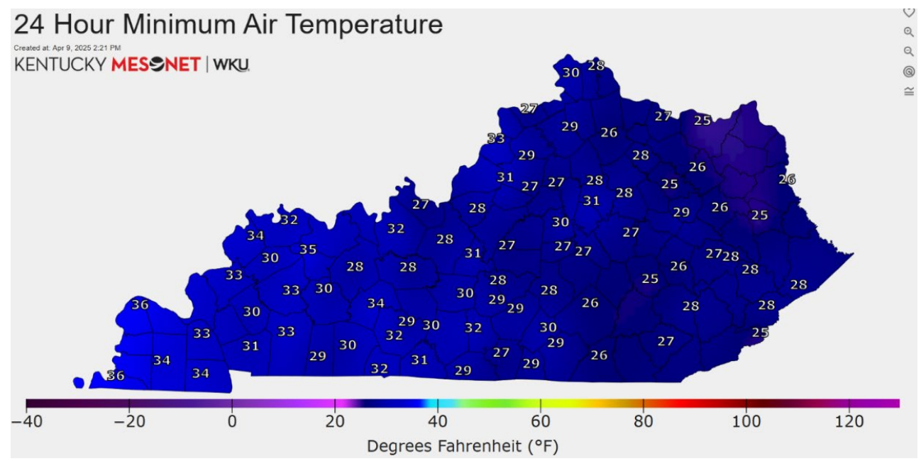
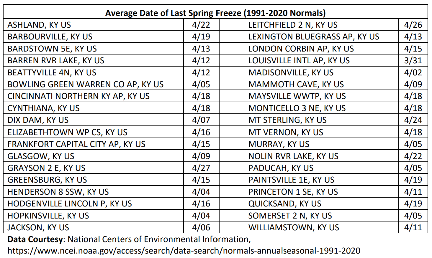
Typically, low temperatures for this time of year range in the low to mid-40s, making these readings significantly below normal—though not entirely unusual. For additional context, I’ve included a table showing the average last freeze dates for various locations across Kentucky. While much of Western Kentucky has already passed this point, Central and Eastern Kentucky are still roughly a week or two away.
Looking ahead, outside of some light rain accumulations on Monday (April 14th), we’re mostly dry until later next workweek. Looking at temperatures, frosty mornings are possible on Saturday and Sunday, but temperatures should rebound nicely, with highs climbing into the 60s and 70s by Sunday. As is often the case during spring, the lingering question remains: how long will the warmth stick around?
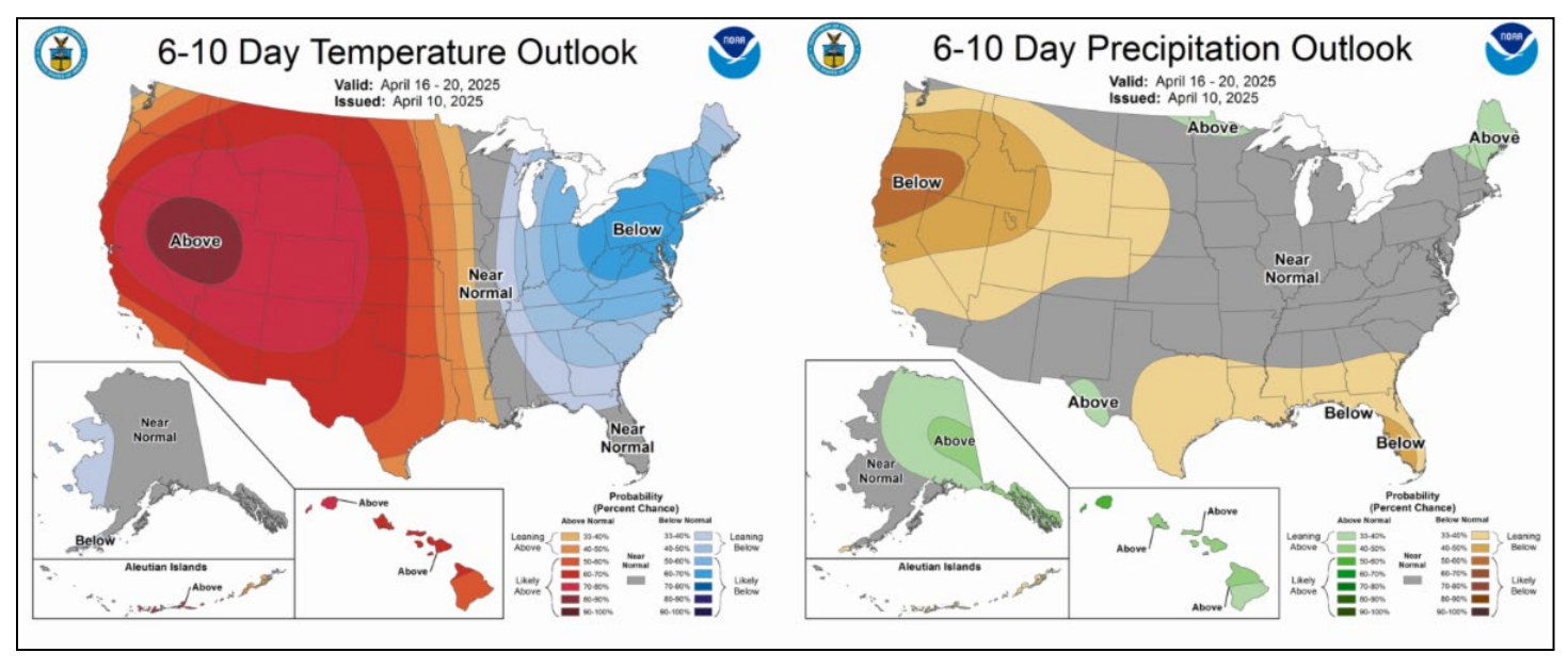
Shifting focus to the long-term outlooks, the forecasts are looking more promising compared to the past couple days! For April 16-20, the 6-10 day outlook predicts below-normal temperatures with near-normal precipitation.
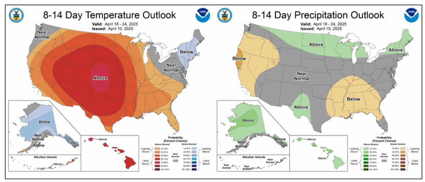
Moving into the 8-14 day outlook (April 18-24), there’s a higher likelihood of above-normal temperatures making a return, paired with below-normal precipitation.
Looking even further ahead to the 3-4 week outlook (April 19-May 2), above-normal precipitation is expected, while temperature trends remain uncertain. What does this mean for planting in 2025? While it's been a slow start, a "glass half full" approach reveals encouraging signs: no indications of severe cold air outbreaks or heavy rainfall events ahead.
Citation: Dixon, M., 2025. A Soggy and Cool Start to Spring Planting 2025. Kentucky Field Crops News, Vol 1, Issue 4. University of Kentucky, April 11, 2025.
Matthew Dixon, UK Senior Meteorologist
(859) 568-1301 matt.dixon@uky.edu
