Fourth Straight Fall, Same Story: Drought Conditions Return to Kentucky
Fourth Straight Fall, Same Story: Drought Conditions Return to Kentucky
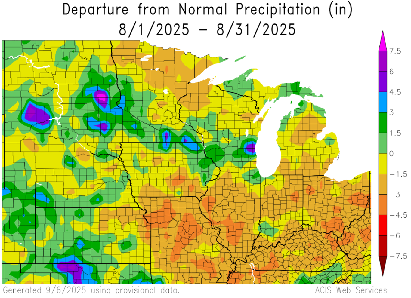
The official data for August 2025 has been released (Figure 2), and as expected, it was the driest August ever recorded in Kentucky. The state averaged just 1.29 inches of rainfall—about 2.5 inches below normal. This marks a dramatic reversal from the first half of the year; through July, it had been our third-wettest January-to-July period on record. Across the state, many locations recorded less than a quarter inch of rainfall. Notably, the Breckinridge County Mesonet station didn’t observe a single drop. It wasn’t just us, either. Looking at precipitation departures from normal, most of the eastern Corn Belt turned dry (Figure 1). Every neighboring state saw a top-10 driest August on record—including Ohio, which, like Kentucky, recorded its driest August ever.

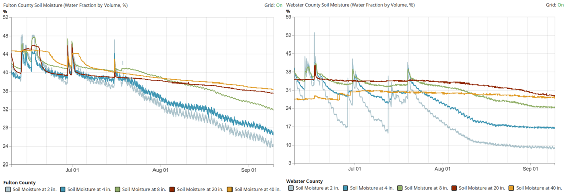
Now that we’ve flipped the calendar to September, some cold fronts have brought some much-needed rain to parts of the Commonwealth—but it hasn’t been widespread. Most of the Purchase and Pennyrile regions have missed out. One example: the Fulton County Mesonet station in Hickman has yet to record anything this month (as of September 11th). It only picked up 0.24 inches in August and just 0.62 inches total since the last significant rainfall, which occurred back on July 15th. Another case is the Webster County Mesonet station, which has now gone 53 straight days (as of September 11th) without recording more than a tenth of an inch. All told, several stations in that part of the state are running 4 to 6 inches below normal over the past 60 days—really taking a toll on soil moisture (Figure 3).
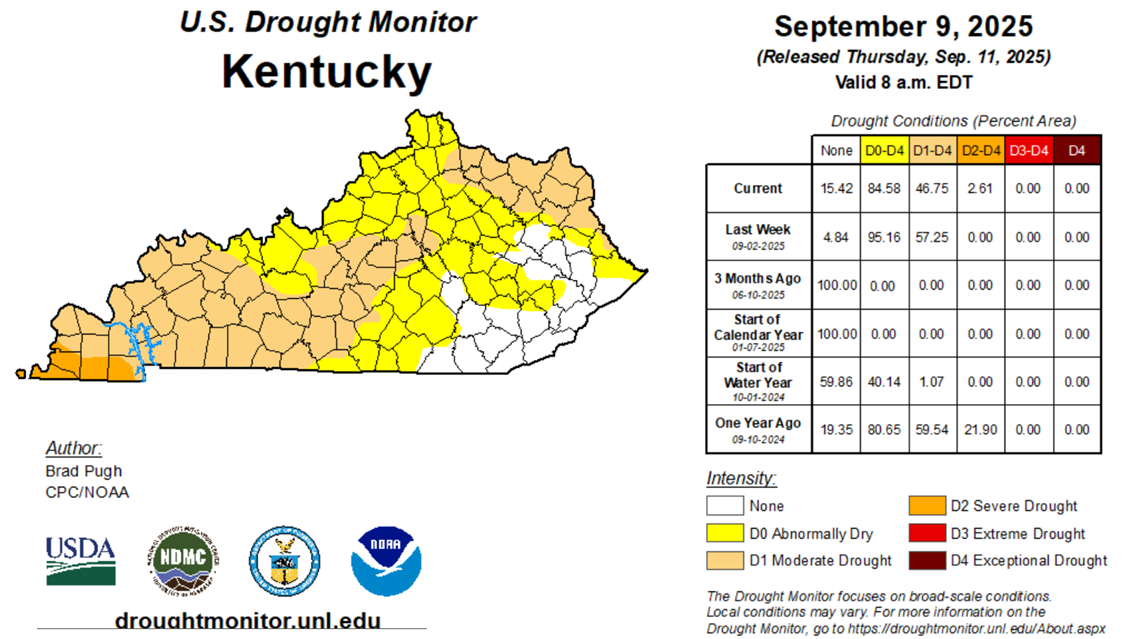
The combination of agricultural and hydrological impacts has led to obvious drought expansion across Kentucky. As of the latest U.S. Drought Monitor update, released on September 11th (Figure 4), about 47% of the state is now classified in drought. Compared to last week, drought conditions have expanded across the entirety of Western KY. The Southern Purchase was even upgraded to a D2 Severe Drought. Meanwhile, significant rainfall led to improvements across Southeastern Kentucky.
This map is redrawn each week with input from the Kentucky State Drought Committee. If you get a chance, consider submitting your own drought observations through the National Drought Mitigation Center’s Observer Reports platform—or just shoot me an email at matt.dixon@uky.edu. Local perspectives go a long way in helping the State Drought Committee get a clearer picture of what’s happening at the local level. Maps and data are great, but real-world observations help fill in the gaps.
Unfortunately, the forecast points to worsening conditions. We’ve been lucky to enjoy a stretch of below-normal temperatures recently, but that relief has come to an end. Summer-like heat has returned this week, with highs climbing back into the 90s across Western Kentucky. And the dry pattern? It’s sticking around. Rain chances over the next 7 days (September 11–17) are nonexistent.
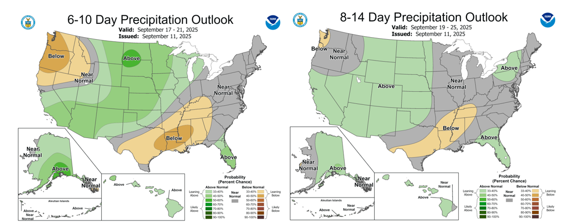
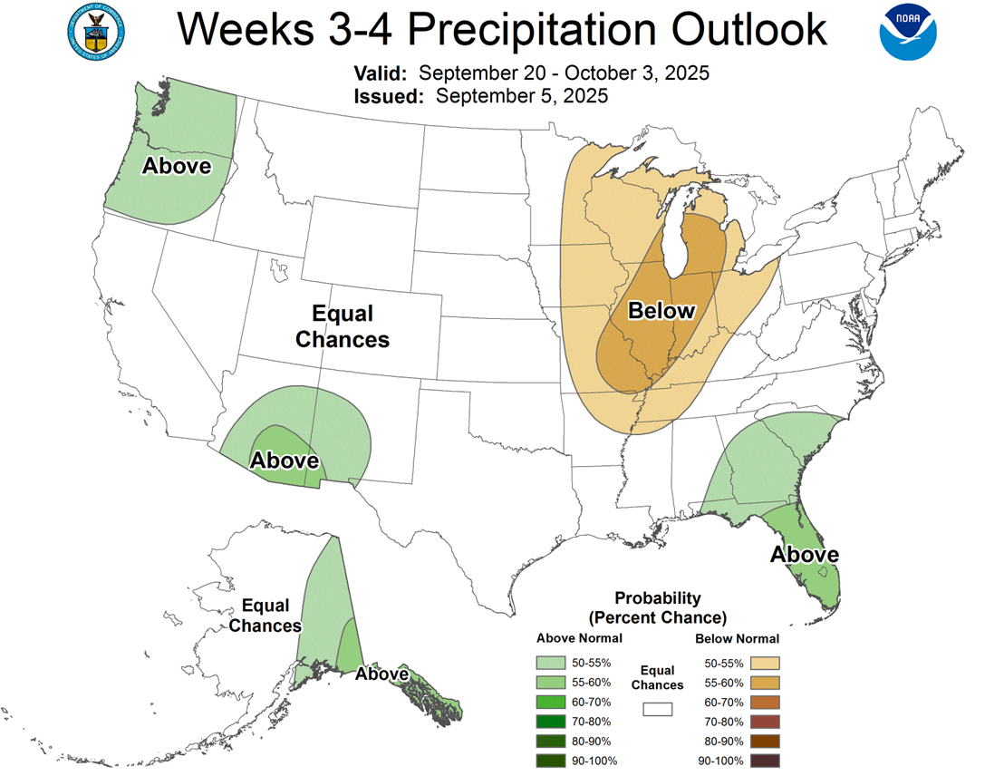
And it doesn’t stop there. Both the 6–10 day and 8–14 day forecasts are leaning toward below-normal precipitation for drought-stricken areas, and even the Week 3–4 outlook is trending drier (maps below). That’s a bit concerning, especially since this is climatologically Kentucky’s driest time of year.
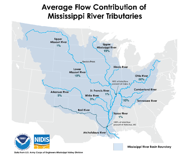
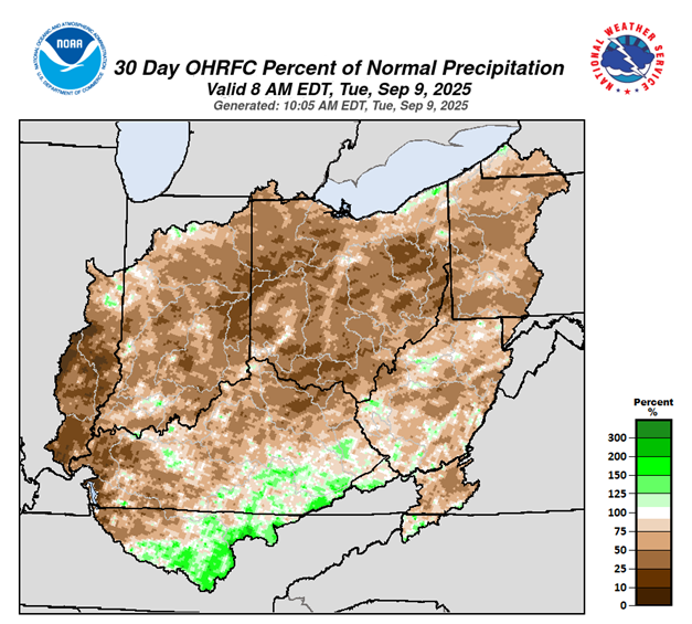
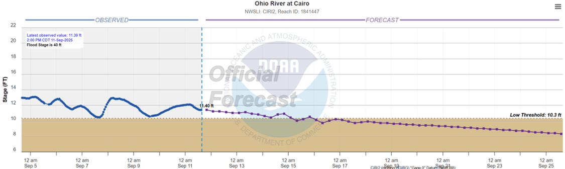
With hot, dry weather expected to persist and humidity remaining low, agricultural impacts are likely to escalate quickly. On top of that, hydrological concerns are also emerging. For the fourth straight year, low river levels could become a concern heading into harvest season. According to flow data from the U.S. Army Corps of Engineers, roughly 50% of the flow into the Lower Mississippi River comes from the Ohio River (Figure 6). Unfortunately, as mentioned earlier, much of the region has seen well-below-normal rainfall over the past month (Figure 7).
Cairo, Illinois is the last gauge on the Ohio River before it feeds into the Mississippi. Current forecasts have the river at Cairo dropping to the low water threshold of 10.3 feet around mid-September. For perspective, during the past three fall droughts, the gauge bottomed out at 4.83 feet in 2022, 4.54 feet in 2023, and 6.43 feet in 2024. So, while we’re still in decent shape compared to recent years, the current forecast for the Ohio River Valley suggests we’ll need to keep a close eye on how things progress—especially with potential impacts on navigation and, ultimately, our bottom dollar.
At the end of the day—as much as I hate to say it—conditions are likely to get worse before they get better. Rapid drought intensification is likely on the horizon, which means we need to stay alert as harvest season ramps up. While harvest should progress quickly, the risk of fire will increase with the continued dry and warm weather. Many of you are already aware, but just as a reminder, here are some helpful fire prevention and safety tips from Iowa State University to help protect your equipment, fields, and crew during harvest.
| Citation: Dixon, M., 2025. Fourth Straight Fall, Same Story: Drought Conditions Return to Kentucky. Kentucky Field Crops News, Vol 1, Issue 9. University of Kentucky, September 12, 2025. |